Drone clarity and property context
Real Estate Aerial Photo Editing
Real estate aerial photo editing for drone images with cleaner color, better clarity, haze reduction, and property context that is easier to understand.
Before and after
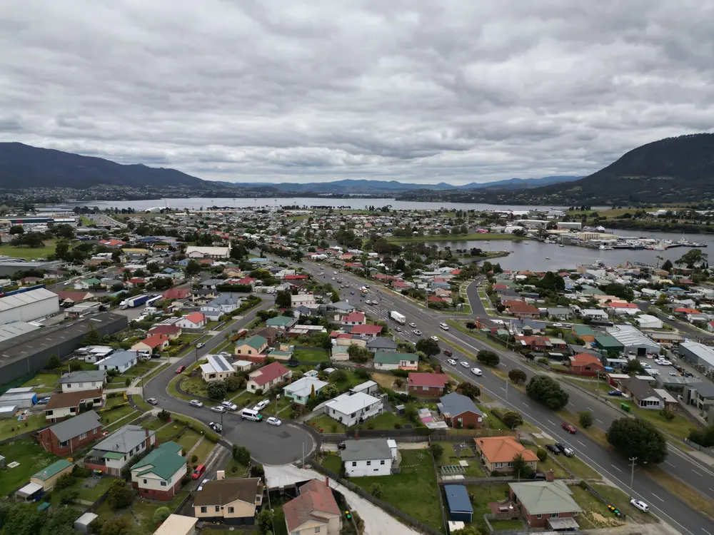
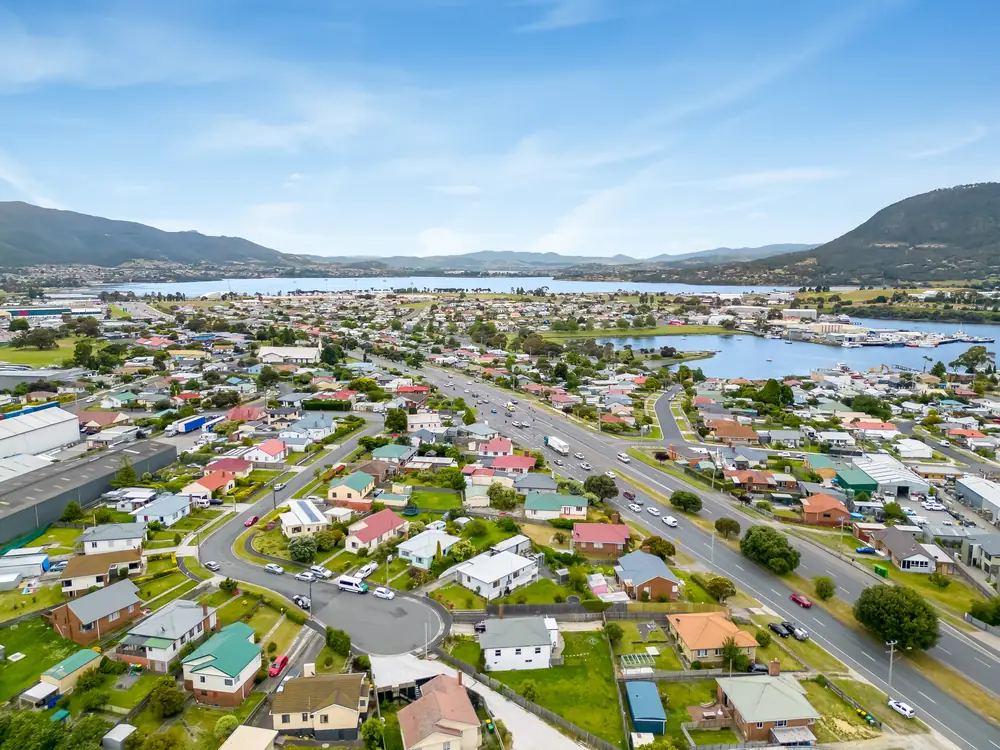
Aerial images should sell location, scale, and context.
Aerial real estate photo editing works best when the drone image explains the property quickly: where it sits, how much land or access it has, what surrounds it, and why the location matters. We clean haze, color, contrast, horizon, roof detail, trees, roads, water, and landscape tone so the image feels polished without becoming harsh or map-like.
Start With a SampleWhat you get
Drone edits that make the property easier to read from above.
Aerial photos need to explain scale, land, access, neighborhood, and surroundings without turning the image into an over-sharpened map.
Haze and clarity control
Distance haze, flat contrast, and soft drone detail are improved without making roofs or trees noisy.
Land and access clarity
Driveways, roads, water, trees, lots, and surrounding context are balanced so buyers understand the setting.
Natural drone color
Grass, roofs, pavement, sky, and landscape tones are corrected to match the real location.
Property focus
The edit helps the eye find the home, land, or commercial feature that matters most in the shot.
Ground-photo matching
Aerial images can be matched to the color and contrast of the interior and exterior listing set.
Listing and campaign crops
Final files are prepared for MLS galleries, brochures, property websites, ads, and social posts.
Color cast removal
Drone color casts from haze, weather, sensor settings, or mixed landscape tones are corrected for a cleaner aerial image.
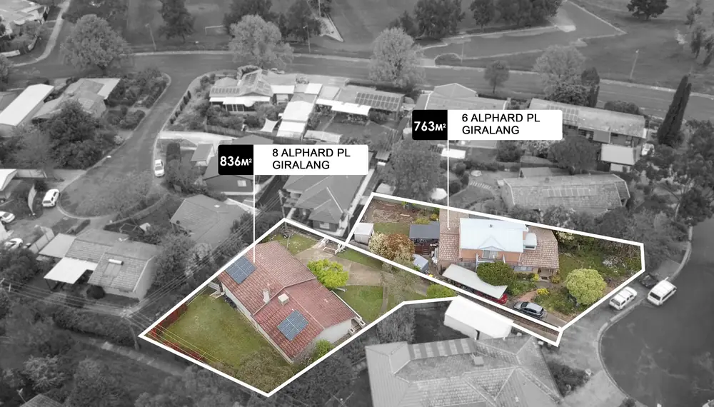
Drop pin and callout support
When you provide accurate placement notes, aerial images can be prepared with clear property focus, pins, or visual direction for marketing.
Perspective and lens cleanup
Wide aerial distortion, tilted horizons, and edge stretching are reviewed so the image feels professional and easier to read.
Aerial distraction cleanup
Temporary distractions such as power lines, tree branches, construction equipment, vehicles, or site clutter can be reviewed for removal.
Brightness and contrast shaping
Drone files are adjusted for brightness, contrast, and clarity so land, roofs, roads, landscaping, and property features are easier to scan.
Who this is for
Best for listings where land, neighborhood, and scale help sell the property.
Drone photographers
Improve haze, color, and clarity without making aerial images look unrealistic.
Acreage and estates
Help buyers understand lot size, surrounding context, access roads, and landscape.
Commercial listings
Make location and property boundaries easier to read in marketing assets.
What to send
Drone edits need context as much as color correction.
Aerial images often carry the whole location story. The edit should make land, access, surroundings, and scale easier to understand.
Send Drone PhotosWorkflow
How drone photos become clearer property context.
Each aerial image is reviewed for haze, land detail, color, property focus, and how it fits with the ground-level gallery.
Read the property story
We look at the angle, land, neighborhood, sky, haze, and the selling point the image needs to support.
Clean the aerial file
Exposure, color, clarity, haze, lens distortion, and distracting elements are handled with restraint.
Shape buyer focus
The property, landscape, access, and surrounding context are balanced so the image is easier to scan.
Match final use
Exports are prepared for listing galleries, brochures, social ads, websites, and presentations.
FAQ
Questions about aerial real estate photo editing.
These answers cover drone color, haze, land context, boundary caution, and matching aerial images to the full listing set.
We can improve exposure, color, haze, clarity, lens distortion, sky tone, landscape balance, and some temporary distractions such as vehicles, power lines, or construction items.
We can help the image guide buyer attention, but any boundary marking should be based on accurate client-provided information and used carefully.
Yes. Send the rest of the listing set or a reference edit if you want drone images to match the property gallery.
Yes. Drone editing is especially useful when location, access, scale, surrounding roads, landscape, or site context help sell the property.
Yes, if you provide accurate placement notes. We can help guide buyer attention, but boundary or location markings should always be based on reliable client information.
Yes. Temporary distractions such as power lines, tree branches, construction equipment, vehicles, or site clutter can be reviewed if the surrounding area can be rebuilt naturally.
Part of the full PixelShouters workflow
Use aerial edits with full property photo editing.
Aerial editing works best alongside HDR interiors, exterior cleanup, sky and lawn, and listing export preparation.