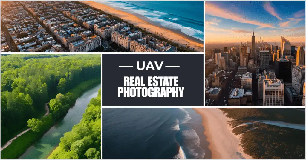
The real estate business has changed a lot in the last few years. These days, technology is a big part of how houses are bought and sold. UAV real estate photography, which uses robotic aerial vehicles (UAVs), also called drones, to take beautiful pictures of homes, is one of the most important new technologies.
This technology has changed the way real estate is marketed by giving users new views, high-quality images, and immersive experiences that can’t be found in regular photos. This complete guide will go over everything you need to know about UAV real estate photography, including its pros and cons, best practices, and how professional editing services like PixelShouters can help make the end product better.
Table of Contents
The Benefits of UAV Real Estate Photography
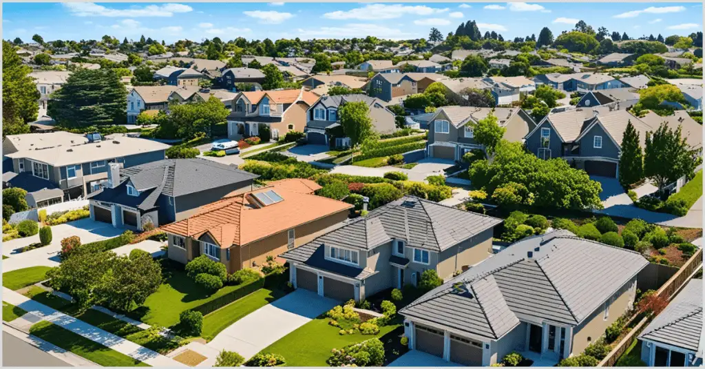
1. Unparalleled Perspectives
UAV real estate photography has one of the most important benefits in that it may capture unusual views emphasizing the best aspects of a property. Aerial views can present the whole property—including its boundaries, landscaping, and surrounding neighborhood—giving prospective purchasers a whole picture.
For instance, ground-based photography might find it difficult to portray the proximity of a waterfront house to the shoreline or the large area of a rural property captured by a drone.
2. Enhanced Visual Appeal
Excellent aerial photographs and movies appeal to buyers aesthetically and establish an emotional link. Dynamic footage—that which captures theatrical pans or sweeping flyovers—that makes properties seem opulent and appealing can be captured by drones. For high-end residences, resorts, or commercial buildings where first impressions are crucial, these images are especially powerful.
3. Contextual Understanding
Aerial photography gives purchasers background that clarifies the location and surroundings of a home. A drone can highlight, for example, the proximity of the property to natural elements like mountains or beaches as well as the local parks, schools, or shopping centers. For consumers looking at several homes, this additional background might be quite important.
4. Cost-Effective Marketing
For real estate agents, the best drone for real estate photography is often reasonably priced, easy to operate, and capable of covering large properties efficiently.
5. Versatility
From modest residences to big estates, unoccupied land, and enterprises, drones are practical tools available for usage in a variety of locations. To suit various business objectives, they can also document movies, still images, 360-degree panoramas, and virtual tours.
6. Competitive Edge
In a saturated real estate market, you must be unique. Properties sold using UAV real estate photography are more likely to draw interest online, where most buyers start their hunt. Aerial view listings often get more hits, shares, and questions, therefore offering sellers a competitive edge.
Challenges of UAV Real Estate Photography

Unquestionably, UAV real estate photography has advantages, but photographers and real estate experts have to negotiate obstacles to reach success.
1. Regulatory Compliance
Many nations have tight regulations on the use of drones for commercial purposes, including house-for-sale photography. For instance, drone users in the US must obtain a Part 107 Remote Pilot Certificate, according to the Federal Aviation Administration (FAA). Particularly near airports or other sensitive places, drones also have to observe policies for airspace, height, and no-fly zones. Ignoring these guidelines may land you in legal hot hot.
2. Weather and Environmental Factors
Sensitive to environmental factors, including high winds, rain, or extreme temperatures, drones can impact flight stability and image quality. Photographers must meticulously schedule shoots to prevent bad weather and guarantee ideal lighting conditions—that is, during the golden hour, early morning or late afternoon, for warm, pleasing light.
3. Technical Expertise
Although drones are becoming more user-friendly, efficient operation of them calls for technical knowledge. To create professionally-grade images, photographers have to become experts in flying controls, camera settings, and post-processing methods. To guarantee consistent performance, drones also need routine maintenance, including software updates and battery checks.
4. Privacy Concerns
Unintentionally capturing adjacent homes or private areas, aerial photography raises privacy issues. Photographers should consider local privacy rules, and permission should be sought where needed to prevent conflicts with neighbors or property owners.
5. Post-Processing Demands
To get a finished look from raw drone footage and photographs, much processing is usually needed. This covers color correction, exposure changes, cropping, and eliminating distractions, including blemishes or power lines. While delivering images that satisfy customer expectations depends on high-quality editing, it can be time-consuming and resource-intensive.
Best Practices for UAV Real Estate Photography
Following these best practices will help photographers and real estate professionals enhance the value of UAV real estate photography:
1. Plan the Shoot
Create a thorough shot list including the main elements to photograph—such as the façade, backyard, roof condition, or neighboring views—before flying the drone. Work with the property owner to make sure the location is ready—that is, clutter cleared and landscaping neat. See weather forecasts and get any required licenses or permits.
2. Use High-Quality Equipment
Invest in a drone with a high-end camera—such as the DJI Mavic 3 or Phantom 4 Pro, with 4K video and 20-megapixel stills. Verify that the drone now has dependable battery life, GPS stability, and obstacle avoidance, among other long-distance shot handling features.
3. Master Camera Conditions
Change camera settings to fit the desired outcome and lighting conditions. For brilliant daylight, for instance, use a low ISO to reduce noise; set a quick shutter speed to get clear shots during flying. Try several angles and altitudes to get the most pleasing views.
4. Capture a Variety of Shots
Combine still photos, films, and panoramic views to vary the material. Showcase the scale of the property using wide-angle views, close-ups to accentuate architectural features, and dramatic flyovers for cinematic attraction. Many images guarantee adaptability in marketing tools.
5. Edit Professionally
Raw drone footage must be post-processed if it wants to become a polished marketing tool. For still photographs, run Adobe Lightroom or Photoshop; for films, run Adobe Premiere Pro or Final Cut Pro. To save time and guarantee consistent quality, outsource editing to expert companies like PixelShouters instead.
6. Stay Compliant
Follow local drone rules exactly and get the required certifications. Respect no-fly zones, stay a safe distance from buildings and people, and carry liability insurance to guard against mishaps or damage.
7. Highlight the Property’s Story
Tell a gripping narrative about the property with UAV real estate photography. Showcase, for instance, the outside features of a house—such as a patio or pool—or highlight its calm rural surroundings. Whether they are families, retirees, or investors, customize the images to the target market.
PixelShouters: Expert Editing Improves UAV Real Estate Photography
In the cutthroat field of real estate marketing, the quality of images of a listing may make or kill it. Professional editing is necessary to produce polished, market-ready photographs and movies, even if UAV real estate photography offers amazing raw materials.
Why would you choose PixelShouters?
To satisfy industry standards, PixelShouters specializes in improving real estate graphics, including drone-captured photographs and movies. Using cutting-edge tools and technologies, their team of expert editors turns unprocessed drone footage into striking marketing assets. PixelShouters improves UAV real estate photos in these ways:
- PixelShouters controls exposure, contrast, and color balance to guarantee photographs are vivid and true-to-life. To make the property stand out, they might improve the blue of a pool or the green of a lawn.
- PixelShouters can replace a boring sky with a brilliant, sunny one should a shot take place on a cloudy day, therefore enhancing the appealing environment.
- Drones might pick up undesired objects such as construction trash, parked autos, or electrical cables. PixelShouters deftly eliminates these distractions so that the property may take the front stage.
- PixelShouters provides stabilization, transitions, and music integration for drone films, thereby producing cinematic, professional-grade footage that captivates viewers.
- PixelShouters provides retouched images within 24 to 48 hours, knowing the fast-paced nature of real estate marketing, and guarantees listings go live rapidly.
- Whether your budget allows for simple improvements or sophisticated retouching, PixelShouters customizes its offerings to fit your particular requirements.
PixelShouters Advantage
Real estate agents and photographers can save time, light their workload, and concentrate on photographing more homes by contracting editing to PixelShouters. Their knowledge guarantees that every picture and video fits the concept of the brand and attracts the target market. PixelShouters is a reliable partner for UAV real estate photography that turns unprocessed drone images into polished masterpieces, therefore enabling properties to stand out in a congested market.
The Future of UAV Real Estate Photography
Future UAV real estate photography looks bright as drone technology develops. These developments and trends should be of interest:
1. AI-Powered Drones
Drone capabilities are being improved by artificial intelligence (AI), which also allows automatic flying paths, real-time obstacle avoidance, and smart photo composition. By analyzing a property and recommending the ideal perspectives, AI-powered drones can help lower the demand for human operation.
2. Virtual and Augmented Reality
Immersion virtual tours and augmented reality experiences are being created using drones. Thanks to drone-captured imagery, buyers may investigate homes in 3D from the comfort of their homes, wandering through interiors or soaring over the landscape.
3. Improved Camera Technology
Further improving the quality of drone images will be developments in camera technology, including low-light performance and 8K resolution. These developments will enable photographers—even in demanding circumstances—to produce crisper, more detailed photographs.
4. Integration with Mapping Software
To generate 3D models and topographic surveys of properties, drones are being teamed with mapping software. Developers and investors who require exact measurements and renderings of land or building sites may find this especially helpful.
5. Eco-Friendly Drones
Manufacturers are creating environmentally friendly drones with longer battery life and less effect as sustainability starts to take the front stage. Longer shots and more coverage made possible by these drones will not sacrifice performance.
6. Regulatory Evolution
Governments are honing rules to strike a mix between safety, privacy, and creativity as drone use increases. Expanded airspace access and simplified licensing procedures could enable UAV real estate photography to be more easily available to professionals.
Case Studies: UAV Real Estate Images in Use
Let’s examine some actual cases to show the influence of UAV real estate photography:
Case Study 1: Luxury Waterfront Estate
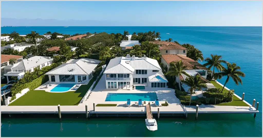
Using UAV real estate photos, a Miami high-end real estate agent promoted a $5 million waterfront estate. Ground-based images cannot adequately depict the panoramic views of the private dock, infinity pool, and proximity to the ocean the drone caught. The house sold in two weeks, and the revised images, improved by PixelShouters with vivid colors and sky replacement, drew foreign purchasers.
Case Study 2: Rural Land Development
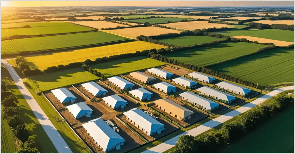
To highlight a 100-acre area for commercial development, a Texas developer employed drone photography. While a 3D model produced from drone data allowed investors to see possible layouts, aerial photographs highlighted the flat terrain, road access, and proximity to a major highway in the area. PixelShouters cleaned the images, which helped to gain project financing.
Case Study 3: Suburban Family Home
One California real estate salesperson promoted a little suburban house using UAV real estate photos. Attractive to families, the drone caught the large backyard of the house, adjacent park, and calm cull-de-zag. PixelShouters removed distractions from the modified photographs, produced several offers, and a home sold above the asking price.
How to Get Started with UAV Real Estate Photography
This is a detailed guide for real estate professionals or photographers wishing to include UAV real estate photography into their workflow:
- Research Regulations: Learn about local drone rules and get required certifications, including the FAA Part 107 license available in the United States.
- Invest in a dependable drone with a high-quality camera and equipment, including extra batteries and ND filters for best performance.
- Learn drone operation by completing online courses or visiting seminars to perfect drone piloting and photography methods.
- Practice editing using tools like Adobe Lightroom or partner with PixelShouters for professional results.
- Start with little tasks to compile aerial photos and videos highlighting your skills in a portfolio.
- Market your UAV real estate photography services to draw customers through your website, social media, and real estate networks.
- Maintaining competitiveness in the sector requires constant awareness of drone technology advancements and legislative developments.
Conclusion
By providing unmatched views, improved visual appeal, and a competitive edge in a crowded market—UAV real estate photography has transformed property marketing. From luxury estates to undeveloped land, drones offer a flexible and reasonably priced approach to highlight homes in their best form. To provide polished images that enthrall buyers, success calls for meticulous planning, technical knowledge, and professional editing.
This process depends much on services like PixelShouters, who turn unprocessed drone footage into market-ready assets to improve listings and increase sales. The opportunities for UAV real estate photography are almost endless as drone technology develops, so offering even more creative approaches to future property marketing.
Whether your business is real estate, photography, or development, adopting UAV real estate photography will change you and produce outcomes. Combining modern technology with professional editing will produce images that not only appeal to consumers but also tell interesting stories that sell homes.
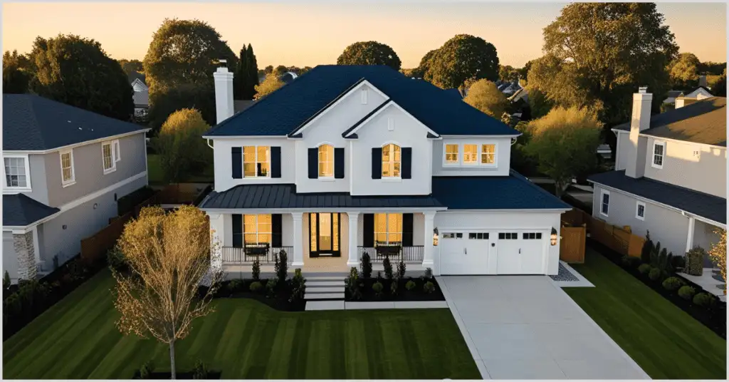
Aerial photos should match the listing set
UAV images can show location, lot shape, views, and neighborhood context. They work best when the color, contrast, sky tone, and sharpness match the rest of the property gallery.
Include aerial images in the same editing workflow so the listing feels consistent from first image to final detail.